DLR
EOC
CORINE
Land
Land Cover
Germany
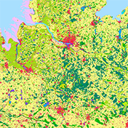
The objective of the pan-European project CORINE Land Cover (CLC) is the provision of a unique and comparable data set of land cover for Europe and the delivery of regular updates to register also the land cover and land use changes over time. It is part of the European Union programme CORINE (Coordination of Information on the Environment). The mapping of the land cover and land use was performed on the basis of satellite remote sensing images.
Items:
Title: CSW
Endpoint: https://geoservice.dlr.de/catalogue/srv/eng/csw
Record ID: 7fa6ffcd-6e17-455a-9679-4d23a858d35d
Record: GetRecord (XML)
Title: CSW
Endpoint: https://geoservice.dlr.de/catalogue/srv/eng/csw
Record ID: 229eccaf-bace-4e93-b8a5-a66568993b0f
Record: GetRecord (XML)
Title: CSW
Endpoint: https://geoservice.dlr.de/catalogue/srv/eng/csw
Record ID: efaf05be-b664-4d9a-bdd8-4104ffd999ad
Record: GetRecord (XML)
Related Datasets:

CORINE Land Cover Change - Germany
2017-03-06


