DLR
EOC
Land cover map
Sentinel-2
Germany
opendata
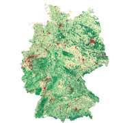
This land cover classfication of Germany was created using Sentinel-2 imagery from the years 2015 to 2017 and LUCAS 2015 in-situ reference data (https://ec.europa.eu/eurostat/web/lucas). It contains seven land cover types: (1) artificial land, (2) open soil, (3) high seasonal vegetation, (4) high perennial vegetation, (5) low seasonal vegetation, (6) low perennial vegetation and (7) water with a spatial resolution of 10m x 10m.
Contacts:
- Michael Wurm (Producer, Processor) Geo-Risks and Civil Security Departement
Properties:
Items:
This layer contains a land cover classification of Germany which was created using Sentinel-2 imagery and LUCAS in-situ reference data (https://ec.europa.eu/eurostat/web/lucas). It contains seven land cover types: (1) artificial land, (2) open soil, (3) high seasonal vegetation, (4) high perennial vegetation, (5) low seasonal vegetation, (6) low perennial vegetation and (7) water with a spatial resolution of 10m x 10m.


