DLR
EOC
Atmos
MetOp-A
MetOp-B
MetOp-C
GOME-2
O3M-SAF
Total Column
Atmosphere
Remote Sensing
Daily
Ozone
BrO
NO2
NO2Tropo
H2O
HCHO
CF
COT
CTP
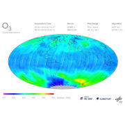
This map shows daily products of different trace gases measured by the Global Ozone Monitoring Experiment-2 (GOME-2) which was launched on board EUMETSAT's Meteorological Operational Satellites (MetOp-A, -B and -C) in October 2006, September 2012, and November 2018, respectively.
A wide range of atmospheric trace constituents are measured, with the emphasis on global ozone distributions. Furthermore cloud properties and intensities of ultraviolet radiation are retrieved. DLR generates operational GOME-2/MetOp Level 2 products in the framework of EUMETSAT's Satellite Application Facility on Atmospheric Composition Monitoring (AC SAF).
References:
Contacts:
- Diego Loyola (Producer, Processor) Atmospheric Processors Department
Properties:
Items:
MetOp-B GOME-2 Total Column Ozone (O3) Composite Layer
MetOp-C GOME-2 Total Column Ozone (O3) Composite Layer
MetOp GOME-2 Total Column Ozone (O3) Composite Layer


